mappery blog

real life maps

Now featuring 1000 ski trail maps from Skimap.org

Posted by mappery on September 8, 2009

trailmaps

mappery has partnered with Skimap.org to bring over 1,000 ski trail maps from the past and present into the mappery collection.  This enormous group of high-quality maps includes both downhill and nordic ski areas from around the world and features a wide variety of artistic styles.

This incredible map collection highlights the fascinating blend of cartography and marketing found in ski maps.  Each map must not only serve as a detailed guide but also as an attractive de-facto brochure to lure visitors.  The best ski trail maps fulfill these dual roles exquisitely and pervade the consciousness of everyone who views them.   As a ski area changes over time, the often annually-updated trail map assumes a third role of historical document, showing growth, different art styles, and even changing trends in skiing like improved glade areas, backcountry access gates, and the rise of the jump parks.

It may still be a bit early to think about the upcoming ski season (except of course in places like New Zealand where things are in full swing), but with this many ski trail maps now easily browsable on mappery, you’d better start exploring them now so when the snow does start falling you’ll know exactly where to go.

Posted in maps | Tagged: | 15 Comments »

maps meet photos: time to explore!

Posted by mappery on June 29, 2009

A map is an incredibly powerful way to get an overall sense of an area, but it doesn’t give an accurate sense of what a place actually looks like.   That’s where photos come in.

Now, by integrating with photo site Panoramio, mappery for the first time unites thousands of maps with thousands of nearby photos to bring your map exploration experience to the next level.

To grasp the exploration power of the map and photo combo, check out the Kaieteur Falls Trail Map of the famous waterfall in Guyana.  This trail map gives a good overall lay-of-the-land, but the dramatic description “plummets 741 feet into the rainforest and is one of the most powerful waterfalls in the world” begs the question: what does Kaieteur Falls really look like?

To grasp the true enormity of the falls, just scroll down to see a collection of nearby photos:

499216

fallsNearby photos now appear on every map page in mappery (except sometimes when there are no photos available near a map).
Here’s another one for you to check out of Dartmoor National Park in England.  Brings the map region to life, doesn’t it?

Would love to know what you think about this latest feature.  If you have any ideas to make the exploration experience even better please let me know.

Have fun exploring!

Posted in updates | 9 Comments »

follow mappery on twitter and become a fan on facebook

Posted by mappery on June 28, 2009

Yep, mappery has finally jumped on the social media bandwagon.    Now you can keep up with the  latest updates about mappery.com and other online map innovations by following mappery on twitter or becoming a fan of mappery on facebook.  Just click the logos below:

twitter

faebook-logo

Posted in news | 4 Comments »

Improved fullsize map viewing

Posted by mappery on March 4, 2009

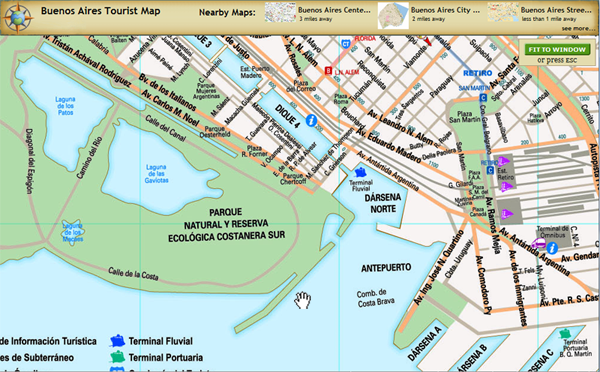
Now when you click to view any fullsize jpg, gif, and png map on mappery, there’s a new, improved way to zoom, pan, see basic info, and easily jump to nearby maps.  Upon initial view, the map is shrunk to fit the size of your browser window.  Clicking the map will zoom in to the actual size and allow you to pan around by dragging the hand (just like in Google Maps).  To re-fit to the size of the browser window, click the ‘Fit to Window’ button in the upper-right.

Also, the top strip of information now shows the map title, the creation date (if known), and the 3 closest maps to the center of the current map.  Clicking one of the nearby maps takes you to more information about that map.   The goal here is to improve the map discovery and browsing process a bit.

Example screenshot of ‘Buenos Aires Tourist Map‘:

map-viewer

Posted in updates | 1 Comment »

Hand-drawn tourist maps from Resort Maps featured on mappery

Posted by mappery on November 27, 2008

rmfi-badge

Over 100 maps of great tourist towns throughout the US and the UK from Resort Maps are now featured in the mappery collection. Each detailed map shows local shops, lodging, restaurants, and other businesses catering to tourists. Resort Map’s distinctive, colorful style highlights the best places to visit in and around town on a single map by employing a liberal interpretation of geography. The Vermont-based company distributes free printed versions of their maps around the US to tourists visiting local businesses (I bet you’ve seen them before, like at the local coffee shop).

After supper, I encourage you to retire to the Resort Maps map room to peruse the extensive collection covering towns in California, Colorado, Tennessee, Puerto Rico and every state on the east coast except Connecticut. For Anglophiles, look closely to find a few English town maps tucked away in there.

Posted in maps | Tagged: | Leave a Comment »

New maps RSS feed

Posted by mappery on October 28, 2008

As a few people requested, mappery just added an RSS feed featuring a rolling list of the newest maps in the collection.  Add this to your favorite RSS reader to keep tabs on the latest map contributions from around the world.

Posted in updates | Tagged: , | Leave a Comment »

Introducing the map room you’ve always dreamed about

Posted by mappery on October 14, 2008

As you’ve moved through life, the dream has never faded: one day, you’ll have your very own room dedicated to your vast map collection.  Like drawing rooms, billiards halls, and personal bowling lanes, the “map room” remains the exclusive personal retreat of the lucky few.  If you’re like me, your map room at best amounts to a dusty shoebox or two full of old maps.

But no more!  mappery introduces your very own map room that will quench your life-long desires.  Well, OK, maybe “room” is the wrong word.  We’re talking a virtual room – your very own map page.

Now, when you sign up for mappery, you get your own map room that’s shaped by your contributions over time.  When you add maps and comments to mappery, they show up in your map room.  The room shows a map view of all of your most recently added maps, as well as a keyword cloud allowing you to quickly jump to a particular type of map.  You can use your map room to keep track of maps important to you and peruse them whenever you want.  (see an example map room)

In a way, that’s exactly what you always wanted, right?

Image source: United Service Club, London 1841

Posted in updates | Tagged: | Leave a Comment »

New map directory for every country in the world

Posted by mappery on August 20, 2008

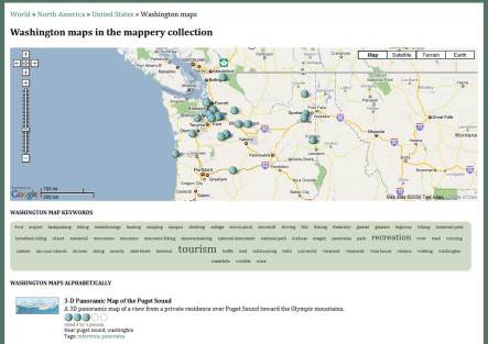
Washington state maps

OK, I’ve been sitting on this one for a bit.  A few weeks ago mappery released a completely new world map directory with several notable features.  Every country in the world (244 of them here) has a separate country map page with the following:

  • map view of the country
  • top keywords of maps in the country
  • alphabetical list of all maps with thumbnails and other info

In addition, there are also new map pages for all 50 US states and the 13 provinces and territories of Canada. These new map pages will make it easier to drill down on a region and find relevant and interesting maps.

Also, it’s worth noting here that when anyone adds a map to mappery, it is now automatically added to the appropriate country or state/province page. If it isn’t, let us know about it and we’ll be sure set things right around here.

Posted in updates | Tagged: , , | 3 Comments »

Love thy PDF map: mappery improves PDF map browsing

Posted by mappery on July 15, 2008

Adobe’s PDF is a great file format for highly detailed maps and its vector qualities scale lines and text impressively. As a result, a lot of the best maps out there are in the PDF format. However, PDF maps are difficult to find and view quickly. No known website currently makes this easy.

To address this problem, mappery now automatically generates thumbnails of PDF maps.  This allows quick and easy browsing of all PDF maps in the mappery collection. Never again will you have to click and load a big PDF map just to get a sense of what it is… just browse around in mappery and get a quick visual flavor of multitudes of PDFs.  This was a total pet peeve for me; look for other new features soon.

To illustrate the improvement, here’s what thumbnails for PDF maps in mappery used to look like vs. what you can see now:

Posted in updates | Tagged: | Leave a Comment »

3D views of map locations: mappery integrates Google Earth

Posted by mappery on May 29, 2008

Yesterday Google announced bringing Google Earth to the web browser. Up until now, to see the amazing 3D views of Google Earth required downloading and installing an application and viewing outside of your web browser. Now, all that’s needed to see Google Earth in your browser is a browser plug in, similar to Microsoft’s Virtual Earth.

Once you have the plug in, you’ll now be able to see 3D views of the map area for every map in the mappery collection. Just click the ‘Earth’ button in any Google Map and the view and controls will switch to the same as in Google Earth.

Seeing map areas in 3D often helps to get a better sense of a place, such as the active Colima Volcano in Mexico (shown above), or mountainous regions like Mt. Shasta in California or the Eastern Alps in Italy and Austria. Also, Google Earth’s 3D buildings are a great additional way to visualize urban maps, like this map of the Las Vegas Strip.

Remember to install the plug in first… also note that for now new map markers won’t appear while browsing around in Earth mode; look for this to be added soon.

Posted in updates | Tagged: , | 5 Comments »

Italy tourist maps galore

Posted by mappery on May 21, 2008

Italy is where tourists go to die.   Having never been, I can only imagine the sheer awesomeness of places like the Sistine Chapel, the Uffizi gallery, the fortress-like towns of Tuscany, the jagged Dolomites, and the canals of Venice.  There are so many tier 1 top tourist destinations in Italy that it’s hard to imagine covering everything in merely a lifetime of vacations.

mappery’s collection of Italy maps helps convey the sheer multitude of must-see cities and towns in this tourist mecca.  Below are links to quality maps of the top 10 tourist destinations in Italy (as determined by About.com).  Use these Italian city tourist maps as the starting point in planning your next Italian vacation.

Italy’s top 10 tourist cities:

1.   Rome tourist map, Rome biking map
2.   Venice street map
3.   Florence tourist map
4.   Torino street map, Torino public transit map
5.   Milan street map
6.   Naples tourist map
7.   Bologna tourist map
8.   Perugia tourist map
9.   Genoa tourist map
10.  Padova tourist map

Posted in maps | Tagged: , | 11 Comments »

Map ratings to the rescue

Posted by mappery on May 19, 2008

Perhaps not earth-shattering news, but mappery has added the ability to rate maps in the mappery collection on a 1-5 globe scale (5 being just plain awesome maps). Anyone can rate a map by clicking through to the map. Also, accessible from the home page is an ordered list of the top rated maps in mappery. As the mappery community and collection continues to grow, ratings will be an easy way to get a sense of the community’s thoughts on map quality.

Posted in updates | Tagged: | 54 Comments »